Sedimentation in the Bovey Basin (2)
(2013 version)
by Tony Vincent
Introduction
I was born in 1937 in Kingsteignton on the edge of the Bovey Basin. As I grew up, I knew the area very well and was educated locally and finished up by gaining a degree in Geology from Exeter University in 1959. After completing my National Service, I got my first job in South Wales with the Opencast Executive of the National Coal Board in1962, which gave me an insight into drilling, section drawing and mineral calculation in stratified deposits. I had a minor car accident in January 1964 whilst returning to Cardiff. When I came down to collect another car, I was lucky that a neighbour that worked for Watts, Blake, Bearne & Co. Ltd (WBB) said that they were looking for a geologist and I applied. I joined WBB in September 1964 at the same time as the merger with Devon & Courtenay Clay Company Ltd (D&C) took place.
For the first six months or so, I worked mainly on WBB’s china clay deposits on SW Dartmoor. After that, I took over control of the drilling operations. In 1965, I was introduced to the North Devon Clay Company (Petrockstow Basin – North Devon) and did some drilling work there. In 1968, the Company was absorbed into WBB. In 1966/7, Newton Abbot Clays Ltd (East Golds, Bovey Basin) was having trouble with river water coming into their quarry, so we drilled the area. NAC was absorbed into WBB in 1968/9 and the River Teign was straightened and their quarry was then developed to the north. Also in 1968/9, WBB became a Public Company, which meant that in 1967, I had to prove to an independent assessor that WBB had at least 30 years reserves, which was not too difficult.
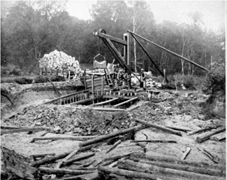
In 1967, deep drilling through the 300 feet of sand at Berry Knowles Farm was proving impossible. This was necessary to plan Adit 10 that would replace the aborted shaft at West Golds. The sand in the aborted shaft was affected by the tides, which came up from the Teign Estuary well into West Golds. Initially, we tried nesting casing in the deep sands, but that was expensive and unsuccessful, so in 1968 we changed to wireline drilling. The inner barrel in wireline drilling could be withdrawn and replaced through the larger diameter drill rods, which stayed in the borehole (Vincent, A., 1971 Drilling Techniques in Ball Clays, Q.J.Eng. Geol. 4{3} pp.241-247). Mud flush instead of water flush was also implemented. The montmorillonite clay mineral in the mud flush would have very much contaminated the kaolinite in the ball clays, so the cores had to be pealed before sampling. However, this proved to be very successful and drilling continued over the whole of the Bovey Basin where the WBB mineral rights were available, with 3 drilling rigs with wireline equipment.
Towards the end of the 1960’s, the Institute of Geological Sciences (then the British Geological Survey) were remapping the areas that included the Petrockstow Basin and the Bovey Basin. In the Petrockstow Basin, Ted Freshney was in charge and he supervised the drilling of deep boreholes on the areas worked by WBB and ECC Ball Clays and was involved in discussions and logging of our boreholes. His assessment was very useful, the trough area contained no commercial clay sequences, which only occurred in the shelf areas, the largest being at the north-east end (North Devon Clay Co.). Richard Edwards was in charge of the survey of the Bovey Basin, but no drilling was done by him. WBB and ECC Ball Clays had to provide their drilling information and discussions with myself in particular were ongoing at the time.
In 1970, Mike Fasham did a Gravity Survey of the Bovey Basin as a PhD thesis (Fasham, M.J.R., 1971 A Gravity Survey of the Bovey Tracey Basin, Devon. Geol. Mag., 108{2}, pp119-130.). Mike had the co-operation of the ball clay companies and myself in particular. Mike produced a model diagram of the rock basin, which suggested a maximum depth of some 4200ft (1200m), a large fault on the western margin running parallel to the Sticklepath Fault system and that the depth contour lines showed general parallelism to the outcrops of the various strata. We had long discussions regarding the density of the Bovey Beds, but at least half of the Basin was not exposed. So Mike took the density of the 2000ft borehole in the Petrockstow Basin, which was 2.0 g/cc, to calculate the depth of the Bovey Basin. That did not take account of the lower density lignite that occurred in the Bovey Basin, so the overall density might have been slightly lower and therefore the maximum depth near to the Drumbridge Roundabout, might be somewhat lower. However, the absolute maximum depth will not be decided until a borehole is sunk near Drumbridge Roundabout, which is unlikely to occur.
My Boss was Dennis Mitchell, Research & Development Manager (later Technical Director and Deputy Managing Director). Dennis came from Stoke-on-Trent, as did many of my colleagues in the Technical Department. Dennis was a brilliant ceramist and chemist, and had already implemented the blending of the seams at Preston Manor, to supply the various ceramic industries (tableware, wall tiles, sanitary ware, refractories, etc.). Dennis had asked me to classify the seams that occurred at Preston Manor, with the other clay areas that we had obtained. However, there was no absolute correlation beyond 400-500 m and clearly more academic information was required, as we were drilling more widely in the Bovey Basin. So Dennis arranged for me to do an M.Phil. at Guildford University in Co-operation with Industry (Vincent, A., 1974 Sedimentary Environments of the Bovey Basin. Unpublished Thesis, University of Surrey). A great deal of academic work had to be done, alongside my role as Chief Geologist and Exploration Manager. The first thing to be determined was how a clay with 85% of particles less than 0.5 microns was deposited.
How did sedimentation of the clays occur?
The first thing that came to mind, was that all the commercial clays had to be deflocculated before use in the ceramic industry. Flocculation is the sticking together of particles by whatever charge is on each particle and this must have happened to the sedimentation of the clays, so that the relative particle size became finer. There are basically two methods of flocculation of kaolinite: 1) Sticking together of particles with negative and positive charges: 2) Flocculation in salty water with a coarser particle size. I did a great deal of experiments in looking at the various types of clay in settling tubes at varying pH and slurry density. The dominant clay mineral in ball clays and china clays is kaolinite, which are platelets with a positive charge on the surface and a negative charge on the edges. When the clays contained colloidal carbon, flocculation took place because of the negative charge of the carbon. The non-carbonaceous silty clays also flocculated, but the quartz also has positive charge and the reason for flocculation of these coarser clays is not known. Basically from my experiments, the carbonaceous clay had a pH of circa 4.0 and needed 25% solids in the slurry to have clear water above the mud line. However, the non-carbonaceous silty clays had a pH of circa 7.0 and only required 8% solids to have clear water above the mud line.
The initial theory of how the sands, clay and lignite were laid down, was based on the Chudleigh Knighton Heath area. To the north-west was sand, as one went south-east, silty clay seams appeared among the sands, then clay and silty clay seams appeared with few sands. Further on the clays became carbonaceous and lignite seams appeared and the commercial clays disappeared and became lignite by Newbridge. The distance from the sands to the lignites was 1200 metres. I discussed this with Ted Freshney and we came to the conclusion that there were three basic environments: a) Outwash fans; b) Turbid shallow lakes or lagoons and c) Back swamps. The outwash fans were where the streams laden with sediment entered the lake or lagoon, where the speed was slowed and the coarsest material was deposited first. That gave rise to the large thickness of poorly sorted, gravelly, muddy sands. The sallow lakes gave rise to clayey silts and clays depending on the concentration of the slurry collecting in the lake and the degree of circulation within the lake basin and became more carbonaceous towards the back swamp. The back swamp environment, gave rise to the lignites by the collection of the floating vegetation in the very shallow water farthest from the entry to the lake. The thickness of the sequence there, showed that the lake basin was there for a good many years and resulted from the sinking of the area as a result of parts of the Bovey Basin lowering due to the Sticklepath Fault system.
Up until the 1960’s, the derivation of the kaolinite for the Bovey Basin, the Petrockstow Basin and even Dorset, was thought to be from the Dartmoor Granite. However, Colin Bristow (ECC and ECC Ball Clays) showed that the ball clays from the Wolladon area in the Petrockstow Basin were derived from the weathering of montmorillonite in the Culm Measures (Bristow, C.M., 1968. The Derivation of the Tertiary Sediments in the Petrockstow Basin. Proc. Ussher Soc., 2, pp. 29-35). My conclusion from this, was that there were three types of provenance for the kaolinite:
- The weathering of country rocks.
- Erosion of hydrothermal kaolin deposits.
- The weathering of feldspar in the Dartmoor Granite.
China Clays (Kaolin) are hydrothermal kaolin deposits and were formed through the alteration of feldspar, just below the then covering of the Dartmoor Granite. The kaolinite content of the hydrothermal deposits was 10-15%, the remainder being quartz and mica. The china clay was washed out and refined.
Classification of Ball Clays
When I joined WBB, Dennis Mitchell had already classified the clays in the Preston Manor area, on the basis of thermal expansion, which was important in the use of clay in the ceramic industry. The following diagram illustrates this classification.
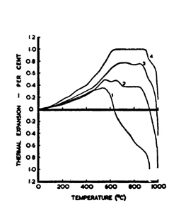
The clays were divided into four distinct groups:
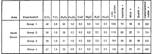
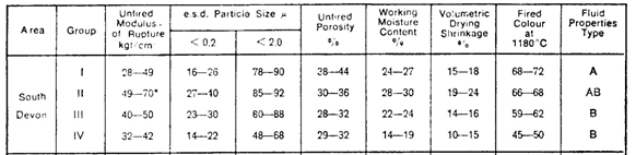
Group 1 – Clays in this group were noted for their excellent fired colour. They were dominantly kaolinitic with low mica and quartz contents, but with quantities of carbonaceous matter. These clays had high fluidity. Historically, clays from this group were termed ‘black’ ball clays.
Group 2 – These clays (the so called ’dark blue’ clays) were again dominantly kaolinitic, but rather more micaceous mineral and quartz than the Group 1 clays. These clays also contain some carbonaceous matter and were generally the strongest clays in the Bovey Basin.
Group 3 – The clays of this group, the so called ‘light blue’ clays, contain rather less kaolinite and higher proportions of mica and quartz and negligible carbon. These clays were extremely thixotropic.
Group 4 – The most siliceous clays that have the highest quartz contents.
The following table shows the mean chemical and mineralogical analyse of the four Groups.
The following table shows the physical properties of the four Groups.
I was not a ceramist or chemist, so I had to rely on my excellent Technical Department colleagues for help in the clay mineralogy and chemistry of the ball clay types, which then gave me a greater insight into the geology. The following paragraphs are based on a paper produced by them (Mitchell, D. & Stentiford, M.J. 1980, Production and Properties of Devon Ball Clays, Watts, Blake, Bearne & Co. Ltd).
Kaolinite
The kaolinite component of the ball clays of Devon is of the type often referred to as ‘b-axis disordered kaolinite’, which is caused by substitution of iron replacing some of the aluminium in the crystal lattice. The disorder is readily recognised in the X-Ray Diffraction (XRD) traces of the ball clays. Various workers have suggested methods by which the ‘degree of crystallinity’ of the kaolinite can be recognised. Of these methods, that due to Hinckley is the one most used. Perfectly ordered kaolinite has a value of 2.0, whilst completely disordered kaolinite has a value of zero. Refined china clay (kaolin) has a value of 1.1. The clays of the Petrockstow basin have a range of less than 0.1 to 0.3, showing that kaolinite derived from the weathering of country rocks are the most disordered. The range in the Bovey Basin is much wider from approximately 0.1 to 0.9. The Group 3 and 4 clays have a Hinckley Index similar to North Devon (0.1 – 0.3) and contain more micaceous minerals than the other two Groups. The Group 2 clays have an Index of 4.0-5.0 and contain less mica. The Group 1 clays are generally 6.0-7.0 in Index and contain less mica than the Group 2 clays. The Group 1 clays are obviously a mixture of particles derived from the weathering of country rock and hydrothermal kaolin deposits on Dartmoor. The Group 1 clays of the Chudleigh Knighton Heath area have an Index of circa 0.8, These clays are also much coarser grained and have mica contents similar to refined china clay, which suggests that they were mainly derived from hydrothermal kaolin deposits. The Parks Seam has the highest Index at circa 0.9 and is coarse grained and holds the least mica, but is full of siderite, which precludes it from use in ceramics.
Micaceous Minerals
From the broadness of the basal reflections of the mica in the XRD traces of most ball clays, it is probable that this micaceous mineral has lattice substitution of iron for aluminium .It is likely that this is the mineral termed ‘illite’. Since this mineral has a very similar particle size distribution to the kaolinite, with which it coexists, it is impossible to separate a pure sample of this material for clear analysis.
A further complication exists with some of the Bovey Basin clays, where there has been occasional XRD traces that appear to contain more than one type of micaceous mineral present. It is possible that the illite also has a small amount of detrital mica carried virtually unaltered from Dartmoor and co-deposited with the kaolinite.
The higher amount of micaceous material present, very much affects the firing characteristics of the clay. Vitrification occurs at a lower temperature as the mica content increases and the fired colour becomes greyer.
Quartz
Much of the quartz found, under the optical microscope, are well-rounded or sub-angular grains typical of sedimentary deposits and are fairly typical of water-worn granitic quartz. Considerable evidence exists, mainly from XRD combined with chemical analysis, to show that the quartz in the ball clays of Devon may be considered to be crystalline quartz with a coating of amorphous silica. In the Bovey Basin 60-65% is crystalline quartz and 35-40% crypto-crystalline silica, whilst in the Petrockstow Basin it is 55-60% quartz and 40-45% crypto-crystalline silica. How amorphous silica forms is not clear, but it is in marine conditions. There are two types of amorphous silica, ‘chert’ that exists in the Culm Measures surrounding the Petrockstow Basin and ‘flint’ that exists in the Cretaceous Chalk throughout England. The nearest present chalk outcrop is to the east of Honiton, some 35 miles away from the Bovey Basin. However, flint is still found as far west as Ivybridge and considerably around the Bovey Basin. That effectively means that at the beginning of the Eocene Period (34-56 million years), chalk was outcropping over much of the area of the Bovey Basin. Some geologists (including me) feel that the Haldon Gravels were caused by solifluction of the chalk and the Greensand, underlying the Upper Chalk, outcrops in a couple of places on the edges of the Bovey Basin. By the later Eocene, the chalk had been largely eroded and the apparent first sediments in the Bovey Basin are the Aller Gravels, which are full of flint and obviously derived from chalk. There might well be chalk and Greensand in the deepest part of the Bovey Basin. The Dartmoor Granite has been exposed since Triassic times (200 million years ago) and the quartz derived from the granite was deposited in the marine environment of the chalk and that resulted in the coating of the quartz grains with amorphous silica and the production of the flint. The Haldon Gravels and potholes in the Devonian Limestone near Kingsteignton, also had some disordered kaolinite similar to the Group 3 & 4 clays in them. That might well have had an influence on the sedimentation of the Groups 3 & 4 clays. The similar clays in the Wareham Basin in Dorset were also surrounded by chalk during their estuarine deposition.
Carbonaceous Matter
Carbonaceous matter occurs in two distinct forms, as colloidal carbon and as lignite. The Group 3 & 4 clays do not contain any carbonaceous matter, whilst in the Group 1 & 2 clays it is prevalent in the sequence. The colloidal carbon was the item that caused flocculation in the latter Groups.
Lignite occurs towards the back swamp area, Composition is complex and 90% of the lignite is 40-60% clay and contains little actual large vegetation. It was only at the end of the back swamp, where floating vegetation collected and that the clay content decreased to below 10%. Very little lignite was saleable and was problem in extraction of the ball clays, the seams being intercalated with lignites. These lignite seams had to be extracted and layered into the waste tips.
The paper by Chandler, investigated the fossil flora found in the lignite mine at Brimley, immediately to the south-west of Bovey Tracey (Chandler, M.E.J., 1957. The Oligocene Flora of the Bovey Tracey Lake Basin, Devonshire. Bulletin of the British Museum {Natural History}, 3{3}, pp.71-123.). The lignites there were probably at the end of several back swamps, but the clays intercalated there had no commercial interest. Chandler discussed the ranges of the various species, some of which had a long period of existence, but the sparse occurrence of Mastixia boveyana, quite distinct from the older Eocene species, indicated a pre-Miocene and post-Eocene Age. Chandler supposed the age to be Middle Oligocene, 28 million years ago.
The climate to produce these lignites was thought to be sub-tropical.
Iron Compounds
Certain specific iron compounds are occasionally present in ball clays. These are usually marcasite or pyrites (FeS2) and siderite (FeCO3). These two compounds occur either side of a geochemical fence, marcasite (usually known as ‘mundic’ in the industry) forms if the pH is 5.0 or less, whilst siderite only forms with a pH higher than 7.0. That depends on the environment in which the iron compounds were formed. When there was much carbon being introduced into fresh water, the pH was lower than 5.0 and the Group 1 & 2 clays contain marcasite growths, usually on fossilised twigs, which were removed in the residues during screening of the clays before ceramic use. If the pH was above 7.0, there was no carbon and possibly salt or brackish water would have been the environment. The Group 3 & 4 clays sometimes sporadically contained siderite concretions of quite large size and these could be extracted when the clay was mined.
Limonite (Fe2O3-nH2O) occurred as a coating on the individual crystals of kaolinite. Substitution of iron within the crystal lattice of kaolinite and illite also occurred. The total amount of iron very much affects the fired colour and the iron compounds when present, produce specking, the specks being from red to black.
Titania in the form of anatase also occurs in the clays. If the total Iron and Titania exceeds 2%, the fired colour would normally fire to a cream/dark cream colour at temperature around 1200ºC.
Slight Feldspar also appears in most of the XRD Traces.
Soluble Salts
Although soluble salts may not arise from one specific mineral, they are commonly found as a contaminant in virtually all ball clays. In the Bovey Basin they range from 40-500 mg/100gm Clay, with an average of 142. The higher amounts can give problems in the ceramic industry and up until the 1950’s, weathering heaps of clay were left exposed for several months to reduce the amount of soluble salts in the heaps. The range of total soluble salts varied considerably from clay to clay and area to area and the highest level clays were probably sedimented in salty water.
The Ball Clay Outcrops
The outcrop of the main ball clay beds has been well known since the Eighteenth Century. It stretches from Little Bradley (closed in 1961), through Chudleigh Knighton Heath, Clay Lane, Newbridge, Rixie Park, Preston Manor, Denistone, New Cross, Broadway, East and West Gold, Mainbow and Ringslade. Richard Edwards after discussion with myself and based on lithology, set up the Southacre Member, which contains the lignites, the Abbrook Member below with no lignites and the Blatchford Sand Member at the southern end of the Basin. I had to create Members based on clay types rather than lithology. My plan of the Basin and the section drawing pages in my thesis are too large to include on-line. These Members showed that the subsidence varied with time and moved around the Basin, with the later sedimentation moving mainly to the west and overlaying unconformably the commercial clay Members to the east. The diagram below was produced in the mid-1970’s, to illustrate the various members.
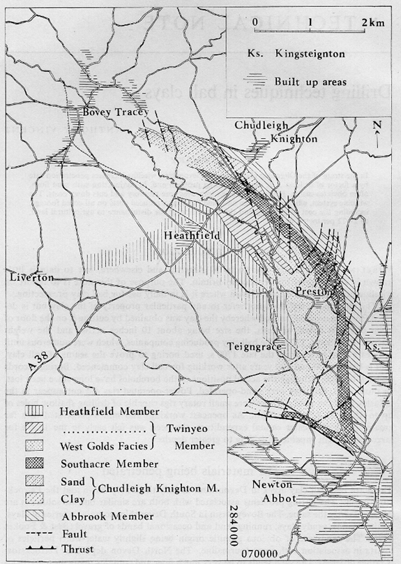
The diagram shows that basically the eastern outcrop is the main area of extraction by opencast pits and underground mines. The faulting truncates the outcrop on the southern western side of the synclinal southern part of the Basin. Faulting occurred well after the completion of sedimentation. Knowles Hill and Highweek Hill are thrust onto the Bovey Basin and that resulted in oblique slip faults with a SW-NE trend in the southern half of the Basin. It is not parallel to the Sticklepath Fault system (SE-NW) until Chudleigh Knighton Heath and Little Bradley at the northern end is reached. The multiple faulting in the Preston Manor area caused repeating of the strata and pushing the outcrop to the north east, which also widens the outcrop area and made Preston Manor the hub of ball clay production.
In the Preston Manor area, the Group 3 & 4 clays are contained in the Abbrook Member. To the south, sands and Group 4 clays dominate and the Group 3 clays appear in increasing quantity as one goes north. The prime Group 3 is the Best Light Blue (BLB) and that dominates at the northern end at Rixie Park. The Southacre Member rests unconformably on the Abbrook Member and the outcrop of the BLB disappears under the Southacre Member at Newbridge. The BLB does not exist to the north or the south in the Abbrook Member, and only appears in the Preston Manor area. Sedimentation obviously came from the south and the disordered kaolinite suggests that it came from weathering of country rocks, the chalk in particular. There being no carbonaceous matter in the Abbrook Member, the climate at the time was not sub-tropical and sedimentation probably occurred in the Upper Eocene/Lower Oligocene circa 34 million years ago.
The Chudleigh Knighton Member rests unconformably on the Abbrook Member and is unconformably overlain by the Southacre Member. The sedimentation came from the north-west and was the nearest to refined china clay of all the sequences in the Bovey Basin. The clays were relatively coarse grained, with a Hinckley Index of circa 0.8 and contained low amounts of mica, which meant that it was suitable for refractory use. However, it also contained siderite and the Fe2O3 content was about 1.25% and it also contained the highest soluble salts, hydroxyl in particular. The evidence suggests that the kaolinite was mainly derived from hydrothermal deposits in the granite in the Sticklepath Fault zone immediately to the north of Bovey Tracey, whilst the siderite and high soluble salts suggests sedimentation in a shallow salt water lagoon that existed over a long period. However, the carbonaceous material and lignite that appeared south of the A38 road, suggests that the climate at the time was subtropical and towards the Middle Oligocene in age. In the 1970’s, there was a very successful Calciner at Preston Manor Works and that processed 30,000 tonnes per annum for refractory purposes from Chudleigh Knighton Pit, However as production moved to Clay Lane Quarry, with increasing carbon and lignite to the south, the Calciner was unable to produce suitable refractory products. The Calciner had to be closed down in 1980/1, because there were no other sources of refractory clays in the Bovey Basin.
The sedimentation of the Southacre Member comes from the south. At the southern end of the basin, at the East and West Golds synclinal area, there were Group 2 and Group 1A (between Group 1 & 2) clays underlain by relatively thin lignites and overlain by a large thickness of sand. As one goes north, the lowest sands moved to sandy clays, clays, carbonaceous clays and lignites and that was repeated as the lake moved further north. The thickest sand was at the southern end of the Basin, whilst the thickest lignites occurred down dip from the Twinyeo/Newbridge area. The sands and the lignites were diachronous (the apparently similar sediment varies in age as one goes north), but the clays were individual in terms of grouping. At Southacre Quarry (Preston Manor), the Group 1 clays dominate, whilst the Group 2 clays occur at the bottom of the 20m thickness of the lignites of the Southacre Member. At one stage, I thought the Group 2 clays were the Upper Abbrook Member, but it soon became clear that they were in the Lower Southacre Member, and they were the prime clays that were mainly historically worked from Newton Abbot Clays (East Golds) to Preston Manor, and beyond Twinyeo they disappeared.
The Group 2 clays had Hinckley Index of circa 0.45 and contained less illite than the Group 3 clays. This suggests that there was some hydrothermal kaolinite included in the dominant weathering of country rocks. The thin sections (to be described later in this article) suggested that the derivation was from the erosion of pre-sedimented deposits to south. The Group 2 clays are the strongest in the Bovey Basin.
The Group 1 clays had a Hinckley Index of 0.6-0.7, lower illite than the Group 2 clays and contained colloidal carbon. Derivation was from a mixture of weathering of country rocks and hydrothermal kaolinite, which were probably pre-sedimented to the south. The fired colour of the Group 1 clays was the whitest in the Bovey Basin. Stratigrphically, the Brimley Member is well above the Southacre Member and there is no connecting outcrop, but the age of the Southacre Member with sub-tropical conditions was probably towards the Middle Oligocene. The Parks Seam that occurred above the Southacre Member in Southacre Quarry, had the highest Hinckley Index (0.9), low illite, coarse grained nature and very low strength, but also contained much siderite, with an Fe2O3 content of 3-4%, which precluded its use in ceramics. Derivation was again from the south and was probably from a pre-sedimented hydrothermal kaolinite into a salt water lagoon.
The western side of the Basin contained no commercial ball clays, with the Great Plantation Member between Heathfield and Liverton consisting of sideritic clay silts, silty clays and sands to a depth of 107 m. Beyond Liverton, the western side of the Bovey Basin is terminated by a large fault, with Rora Woods rising up beyond the fault. At one stage, the sedimentation extended further to the west, but without commercial ball clays being laid down. The main outcrops of the worked clays is to the east of the Basin, plus a short outcrop on the SW side of the southern syncline (West Golds and Ringslade).
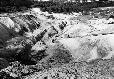
The following picture is an aerial photograph taken in the late 1990’s of the eastern outcrop, looking in a south easterly direction:
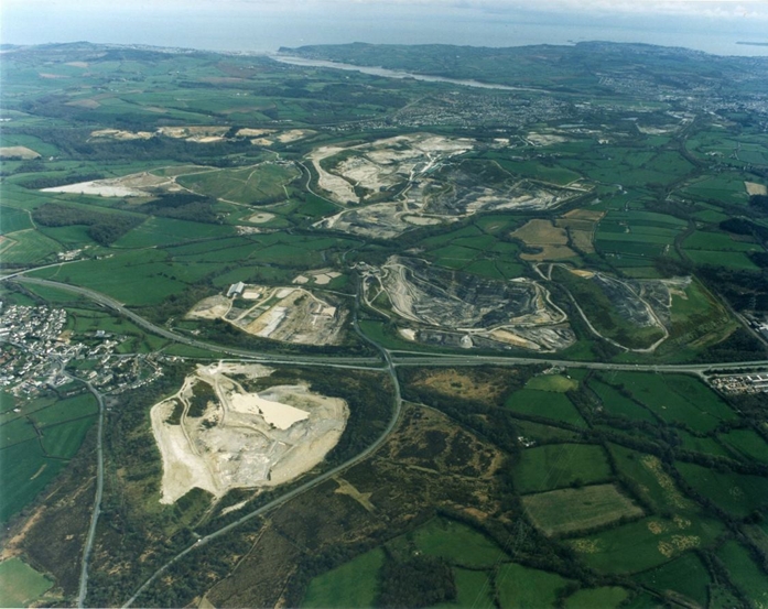
In the lower left corner is Chudleigh Knighton Pit, whilst to the south of the Pit, the A38 dual-carriageway crosses the picture. Beyond the A38 is Clay Lane Quarry to the left and to the right is Newbridge Quarry (ECC Ball Clays, now Imerys). Beyond that is the Preston Manor complex and the continuing outcrop swings around to the right. Beyond Preston Manor is the town of Kingsteignton and above that is the Teign Estuary. In the top left is Teignmouth and Shaldon at the mouth of the Teign Estuary.
The next aerial photograph shows the Preston Manor area, looking in a northerly direction in 1998. Sibelco had taken over WBB in the mid 1990’s and they gave me early retirement in 1997, but retained me as a training consultant for 2½ years.
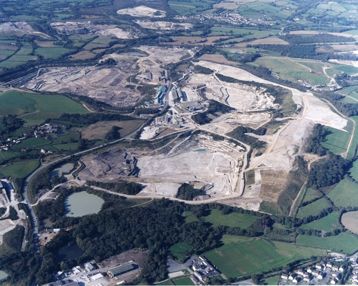
The pit in the lower centre is John Acres Lane Quarry. The two ponds that can been seen were working the Group 2 clays, probably in the first part of the twentieth century. At the southern end of the pit, the sands began to dominate the Group 3 & 4 clays and the pit was not taken any further south. The dark area to the left of the pit are the Group 2 clays and lignites, which continue to the north under Preston Manor Works and the western edge of White Pit.
Above John Acres Lane Quarry is White Pit, to the right of Preston Manor Works. That quarry was mainly Group 3 & 4 with no lignite or carbonaceous matter, Hence the name ‘White Open Works’ or ‘White Pit’. The Group 2 clays were under the Works, but repeated outcrops occurred due to faulting. Up until 1960, underground shallow shafts (up to 150 feet) working took place, but from 1960-1999, adits were in place, working the Group 2 clays and Best Light Blue down dip westward, from Preston Manor Works to the River Teign.
To the west (left) of the Works is Southacre Quarry. The darker right hand side are the Group 1 clays intercalated with lignites. The yellowish band in the middle of the quarry is the sands above the Parks Seam and to the left is the Gooshams Member containing Group 1A clays.
Above the Preston Manor area is Newbridge Quarry and Clay Lane Quarry, whilst Chudleigh Knighton Quarry is top centre.
The road running through the Works is the B3193 (Kingsteignton to Chudleigh) and that crosses the outcrop of the Group 2 and Group 3 clays diagonally and freezes considerable reserves that exist under the road and the barriers and batters. In the mid 1970’s, we planned and got planning permission to divert the B3193 to the east, The picture shows the tip that was planned beyond the outcrop of the commercial clays and the road diversion would go round the tip and arrive to the road corner in the bottom right of centre of the picture. We were going to implement this circa 1992, but the recession and the takeover by Sibelco in the mid 1990’s stopped us doing it. However, Sibelco completed the diversion in 2014.
The following diagram, shows the West Golds area, based on a 1950’s 1/2500 OS map.
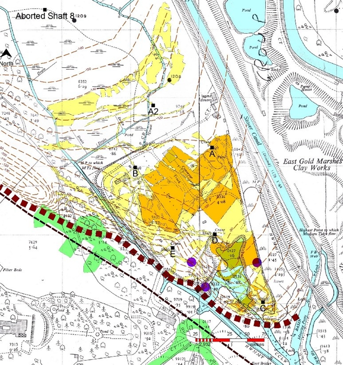
D&C worked underground at West Gold from 1932 to the 1960’s. Opencast pits were not possible due to the fact that the tides came up to mid-way in West Golds and flowed through the overburden and sand that overlay the seams of clay being extracted. The purple circles show inrushes of water that occurred in 1956/7. There were 6 shafts that D&C operated (A, B, C, D, E and A2). Shaft A commenced in 1932, whilst A2 was the final operational shaft. There were two seams that were being extracted, called BWS by D&C and they were Group 1A clays. Above the two BWS seams was 6m or so of more siliceous clay before the overlying sand. The light yellow shows where only one seam was extracted, whilst the dark yellow shows where both BWS seams were extracted. The brown square line shows where the outcrop of the BWS seams was under the overburden. The underground contours shows the SW side of the syncline, had very high dip where Knowles Hill and Highweek Hill were thrust onto the Basin. A & B shafts had very little dip and was the main area of mining both seams, whilst E shaft worked the high dip area. The A2 shaft to the north had moderate dip and only one seam was worked. The green areas show the new hospital and the recent Jetty Marsh Road roundabout.
There were only three other areas that were worked outside of the eastern outcrop. The earliest was the Candy’s Pit at Heathfield, to supply clays for the Tile factory. It was worked in the 1920’s and 1930’s and is now a lake that has been there for a number of years. The only other pit in the main Basin is the Stover Pit of ECC Ball Clays, immediately to the south of Stover School, but we have no information on its working in the 1970’s and 1980’s.
The third area is outside the main Basin and to the south of Newton Abbot in the Decoy area. The occurrence of this is a faulted outlier of the Bovey Basin and the following diagram, based on a late 1930’s 6inch OS map, is shown below.
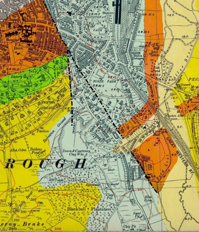
The colours on the map represent the ages of the rocks of the Decoy area. The Orange is Permian (299-251 mya), the Green is Greensand (Lower Cretaceous 145.5-65.5 mya) and the Yellow is the Aller Gravels (Eocene 55.8-33.9 mya). The Light Blue is the Bovey Beds and the Light Yellow is Alluvium. The known faults are also shown by the dot and dash lines. The Bovey Beds and the Aller Gravels appear as far south as Kingskerswell and there are quarries working the Aller Gravels to the east of the A380 road just to the north of the village, which shows that the Bovey Basin at one time extended much more to the south along the Sticklepath fault system. The Sticklepath Fault emerges between the Rock Walk and Torre Abbey Sands in Torquay. Clearly, there has been a lot of upward movement and erosion since sedimentation, but the Aller Gravels and the Bovey Beds are either faulted against or rest on much older rocks.
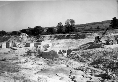
The dip of the Bovey Beds at Main Quarry was 1in 4 to the east. Although there was only limited information available, the prime clays appeared to be Group 2, interspersed with a couple of lignite bands, which suggests a Middle Oligocene age. The prime clays were overlain by sandy clays and sand, whilst they rested on the Lappathorn Member, which was composed of red stained clays and sands. The area was worked by square pits, shafts and three or more quarries. In the diagram, Main Quarry is just to the west of Vale Road and Magazine Lane Quarry is marked ‘Clay Pits’ to the west of the end of the Decoy Terrace. There were clay pits and shafts to the south, but there was no relevant map available to extend the geology of the diagram to the south. However, 4-500 m south of the diagram was South Quarry. The northern part of the quarry was worked earlier and is still a pond, but the southern part was worked in the 1940’s and 1950’s. The dip was lower, but still to the east.
 |
 |
The picture above to the left is of a square pit at the beginning of the 20th Century, whilst the picture to the right shows Main Quarry in the 1950’s.
The above picture shows South Quarry, looking north-east towards Aller and Milber circa 1948.
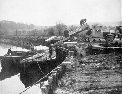
D&C was formed in the late 19th Century and were the sole producer in the Decoy area. It was their only working area until 1920, when they purchased other mineral rights and land in the main Basin. The extracted clay was taken down to Newton Abbot Quay, by horse and cart initially and then by early small Lorries in the 1920’s. The following picture shows a small lorry loading a barge at Newton Abbot Quay in the mid 1920’s. The two barges shown, were then towed down to Teignmouth by the power boat alongside the barge.
By the mid 1960’s, the Decoy area was almost exhausted and there was potential subsidence with the Vale Road residences, so the area was closed for further clay extraction. In 1968, Main Quarry and Magazine Lane Quarry were allowed to flood and the ground around the area was upgraded in association with the Council and is now known as the Decoy Country Park. South Quarry, further to the south, was later backfilled and became a football ground.
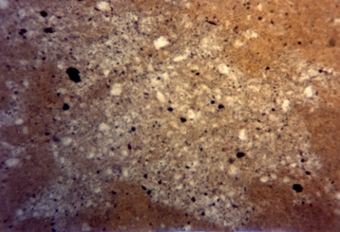
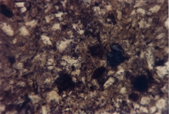
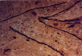
Thin Sections
At the time, I was very much aware of the importance of thin rock sections for investigation of rock mineralogy. However, clay was too soft and friable to allow cutting, grinding and polishing to be able to produce clay thin sections. After investigation of techniques for thin sections of soil, I realised that Carbowax had to replace the moisture content in the clay. One inch cubes of clay were taken from the centres of borehole cores. Carbowax melts at a temperature of 60ºC, so the undried samples were then placed in a deep tray containing molten Carbowax and placed in an oven for about a week, at 60ºC. The Carbowax, being easily soluble in water, moved into the samples by diffusion. The tray was then taken from the oven and the samples removed from the molten wax and allowed to cool. The cooled sample could then be sawn and ground in the normal way, except that kerosene had to be used instead of water and the slices had to be mounted on the glass sides using Araldite. Final grinding with carborundum powder mixed with kerosene proved to be difficult due to the softness of the slice and the thin sections were only ground down to 40 microns. The process was successful, no kaolinite crystals could be seen, but some were interesting.
 |
 |
The thin sections were inspected via a polarising microscope. The picture above to the left (Plane Polarised x 67) shows a silt pod in a silty clay of the Abbrook Member. The silt pod shows a large variation in the grain size of the quartz and dark tourmaline crystals, whilst they are much smaller in the surrounding clay. These silt pods were considered to have been eroded from pre-sedimented beds to the south.
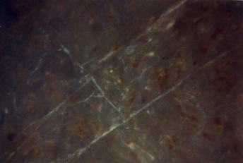
The picture above to the right (Plane Polarised x 67) shows a tourmaline rich muddy sand from the Stover Member and that would have been derived from the Dartmoor Granite initially.
 |
 |
The two pictures above were from the Group 2 clays at the base of the Southacre Member at Preston Manor. They were both taken in Normal Light, the one to the left is times 2½ and the one to the right is times 4. They show breciaition and pieces of clay that must have been eroded from pre-sedimented clays to the south.
 |
 |
The two pictures above (Plane Polarised x 67) show Group 1 carboncaeous clays from the Upper Southacre Member, both being Group 1 clays. The left picture shows another type of clay breccia, with carbon-rich streamlined pieces of clay surrounded by a lighter matrix that shows apparent flow structures. The right hand picture show a slightly silty clay with filled vegatation.
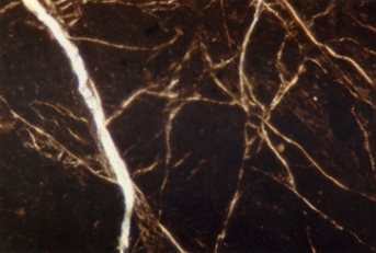
The two pictures above show cracks (Crossed Nicols x 67). The left hand picture shows tectonic cracks in a Group 1 clay in Southacre Quarry, where there were several faults. The right hand picture shows syneresis cracks in the Group 2 clays at the base of the Southacre Member. Syneresis is the expulsion of a liquid from a gel like substance. Syneresis cracks form by the contraction of clay in response to change in salinity of the liquid surrounding the deposit.
 |
 |
The two pictures above (Plane Polarised x 67) show a vegetation fossil (pollen?) in the Group 2 clays. The right one is sheared and has tectonic cracks alongside.
The History after Sedimentation
When I was at University, geographically Devon and Cornwall were described as being rejuvenated. This meant uplift and as it occurred the rivers cut down with youthful valleys into the terrain and finished up being described as “rias” at their mouths. In Devon, Plymouth Sound, Salcombe-Kingsbridge and Dartmouth-Totnes are rias. During the last Ice Age, which peaked 21,000 years ago, sea level dropped by about 50 m. At the end of the Ice Age about 11,700 years ago, sea level rose and reached a peak 4,000 years ago. That meant that the rias were flooded and have deep anchorages, but very steep sides and that makes Devon and Cornwall very much up and down.
The uplift probably took place in the Miocene circa 23 to 5 million years ago, and that caused the thrusting of Knowles Hill and Highweek Hill onto the SW corner of Bovey Basin and the faulting in the Basin and its surroundings. Since then, a great deal of erosion has taken place, which has resulted in the present landscape. During my academic work, I also looked at the Geotechnical Properties of ball clays. The Liquidity Index showed that the clays were over consolidated and after discussion with Peter Fookes (University of Surrey), I was convinced that the Preston Manor clays had been stripped of 50m of overlying strata.
During the Pleistocene (2.5 million years to 11,700 years) there were a number of Ice Ages and Interglacial Periods that saw a great deal of erosion and settlement of overburden from the rivers . The River Teign at one stage probably flowed south and emerged into the sea at Torbay. However, river capture resulted in a right angle turn at Newton Abbot, at the south end of the Bovey Basin. The estuary now goes east, to emerge into the sea at Teignmouth. The period that saw the river capture, I can’t remember, but a seismic survey and boreholes for the A380 Kingsteignton By-pass revealed that the rock basin under the estuary was much lower than the present surface of the estuary. The buried channel of the Teign Estuary drops from -10.2m at the head of the estuary to -22.9m at Teignmouth. The estuary is floored by Devonian slate for most of its length, but New Red Sandstone breccia underlies the Teignmouth foreshore. As the sea dropped about 50m during the last Ice Age, that probably resulted in the deeper Teign Estuary channel, so river capture was certainly before that period. As the sea level rose, the Teign Estuary started to have settlement, initially gravels and then silt and fine sand. By 4,000 years ago, sea level reached a peak and the tidal flow reached as far as the West & East Golds (“golds” are swamps or marshes). That resulted in the rivers dropping their coarser sediment on top of the Bovey beds and that resulted in what was described as overburden. Around the Teign at the southern end of the Basin, the overburden was 7-9m in thickness and contained many boulders. Further north the overburden around the R. Teign and R. Bovey was not so thick, but overburden had to be removed before the clay could be worked. The initial clay workings were discovered by ploughing for farming and contained little or no overburden. It was not until the 1940’s that mechanised overburden removal took over, so the early opencast sites had little or no overburden or were worked by square pits or shafts through minor overburden.
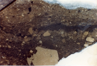
The last Ice Age also affected the clay that was interstratified with lignite. The previous ice ages and interglacial periods had also laid down overburden, but not to the same depth as East & West Golds. SW England was not glaciated, but subject to Periglacial conditions. The glaciers came down as far as the Thames-Shannon line, so Devon did not suffer any glaciation. However, permafrost that is freezing and thawing to a depth of circa 10m was common for many years. That produced sharp uprising of the clays between pockets of overburden and a paper was produced to explain the phenomena (C.A. Jenkins and A. Vincent, 1981. Periglacial features in the Bovey Basin. Proc. Ussher Soc., 5, 200-205). The paper was produced to explain the surprising contortions in the start of Clay Lane Quarry in 1978/9. The gravel pockets were 20-25m in diameter and penetrated to a depth of 12-13m from the original surface. In between were “anticlines” of clay that almost reached the surface. The origin of the structures was deduced as being the difference in the moisture content of the clays and lignites, with lignite being generally double that of clays. When freezing occurred, the water expands to form ice and in the lignites expansion was much more than the impervious clays. That meant that the plastic clays were pushed upwards and on thawing, the lignites contracted and at their outcrop the overburden sank a little. Over many years, that resulted in the “anticlines” of clay being separated by deep gravel pockets. Below about 10m the dip and strata returned to normal. The Abbrook Member containing no lignites was unaffected, but the Ball Clay Heritage Society early photographs of quarries in the Southacre Member that do contain lignites and many show the “anticlines” of clay and gravel pockets. The clays in Chudleigh Knighton Quarry, 200m to the north of Clay Lane Quarry, did not contain lignites and the clay beds were also unaffected by the permafrost.
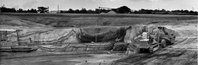 The picture above shows overburden being removed at Southacre Quarry in 1953. The face has a clay “anticline” and a gravel overburden pocket to the right alongside it. Underneath the gravel pocket appears to be collapsed lignite beds.
Most of the early workings of ball clays, were discovered by farm ploughing on the heads of the clay “anticlines”. Most of these were the Group 2 clays, and numerous ponds exist between Preston Manor and East Golds. The first workings of the clays was about 1675 for clay tobacco pipes and I think the first workings were on a clay “anticline” at Clay Lane Quarry. There was a line of very old shallow workings that went north to south before the quarry was opened. The extracted clay was carried by packhorse to Exeter for manufacture and export of the tobacco pipes.
Conclusion
By 1973, the occurrence of the commercial clays was determined to be the eastern outcrop and the tip of the southern syncline, so further exploration ceased. I became more involved in production planning and quality control and academic work went out the window. In 1973/74, WBB purchased the largest of the German plastic clay companies (Fuchs) and a small French company. I became very involved in this and started spending a lot of time abroad, initially in Europe. By 1985, I became a Director of WBB Mineral Services, which was looking for ceramic clays around the world, to confirm that there was not another Bovey Basin anywhere. We had Joint Ventures in Thailand, China and Indonesia and I was exploring other countries in SE Asia. In the late 1980’s WBB purchased United Clays, the second largest of the USA plastic clay producers, mainly in western Tennessee. I became very much involved in that and explored Mexico, Surinam, Venezuela and Brazil, until I was given early retirement in 1997. However, I was the Secretary of a Planning Committee, which had to present a year by year forecast of the specific clays available for the technical sales of the clays being supplied to our customers by Devon Clays. That occurred from the late 1970’s and that gave me a greater insight into the sedimentation of the Bovey Basin. It changed some of my views, particularly the derivation of kaolinite, but there was no further academic work done, so some of my conclusions are a matter of conjecture.
My conclusions are as follows:
1) The quartz grains in the Bovey Basin were derived from the Dartmoor Granite. The amorphous silica coating of the quartz grains in the Abbrook Member was probably created through sedimentation into the eroded marine Cretaceous Chalk. The quartz grains in the later uncommercial members was not investigated for amorphous silica coating and probably doesn’t contain it.
2) The kaolinite was derived from weathering of country rocks or hydrothermal kaolin deposits (china clay type sources) on the Dartmoor Granite. The Abbrook Member was produced from weathering of country rock and sedimentation appeared to have come from a southerly direction. The Chudleigh Knighton Member was derived from erosion of hydrothermal kaolin deposits on Dartmoor and came from a north-westerly direction. The clays of the Southacre member were derived from a mixture of the two types of kaolinite and came from a southerly direction. The uppermost members of the Basin contained no commercial clays and lie unconformably to the west. That means the main area of production was the eastern outcrop of the commercial members.
3) Some of the clays show brecciaition in the thin sections and show that some clays were partially derived from eroded clay beds already sedimented to the south.
4) The Bovey Basin at the time of sedimentation was much larger to the west and to the south.
5) Uplift of Devon probably took place in the Miocene and resulted in the thrusting and faulting in the Bovey Basin. Erosion since then has produced the present situation.
6) Overburden was produced by the interglacial periods in the Pleistocene.
7) The clay “anticlines” were produced by permafrost, where the clays were interstratified with lignites.